Happy World Oceans Day!
The United Nations has designated today (8 June) an international day to celebrate our oceans, helping raise public awareness of the profound roles they play in our lives.
It’s often claimed we know remarkably little about Earth’s oceans, despite the fact that they cover more than 70% of the planet’s surface.
NOAA (the USA’s National Oceanographic and Atmospheric Administration) states that a whopping 95% of the underwater world remains unexplored (though it does depend a little on what you mean by unexplored).
Few regions of our planet’s surface remain more mysterious than the deep ocean floor, where colossal water pressure and total darkness combine to create a highly inhospitable environment for life – and for scientific instruments.
World Oceans Day is an apt moment to take a look at two objects in the Science Museum Group Collection – one of which was acquired for the national collection just a few months ago – which have helped to bring the ocean’s murky depths into clearer view.
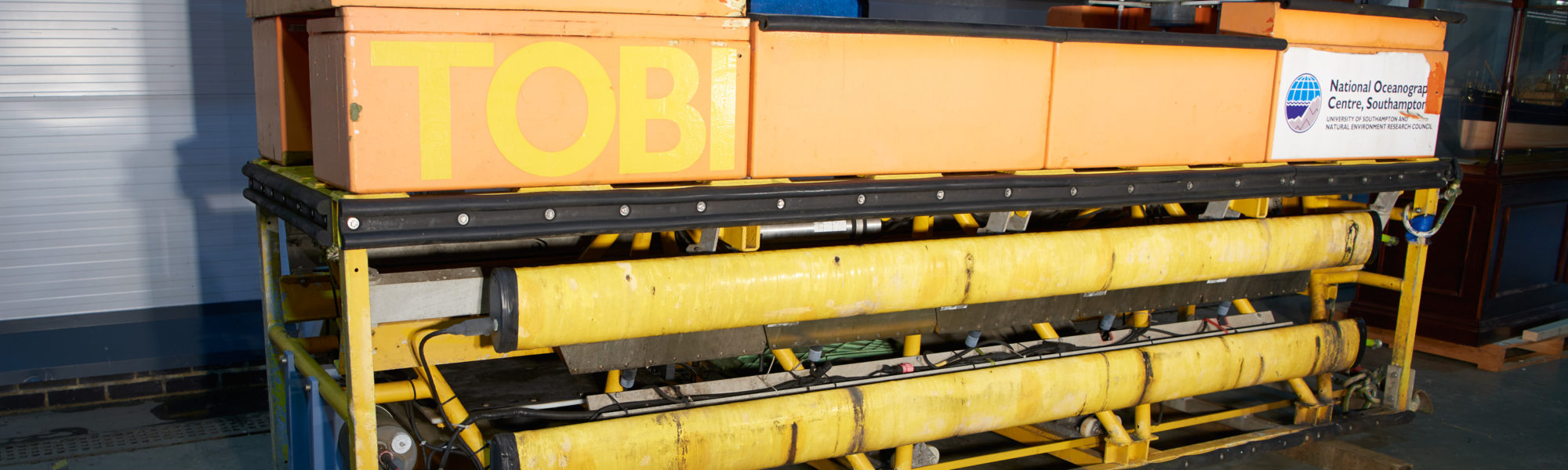
First, meet TOBI.
Imaginatively called a Towed Ocean Bottom Instrument, TOBI was built in the 1980s by the UK’s Institute of Oceanographic Sciences (IOS) in the village of Wormley in the Surrey countryside.

TOBI was designed to launch from a research ship and be towed at the end of a vast cable, up to 8 kilometres long, ‘flying’ around 100 metres above the sea bed.
Its side-scan sonar arrays used acoustic signals to gather data about the topography of the ocean floor, which were transmitted back to the ship via the cable and used to build up maps of the submarine surface. TOBI could also carry instruments for collecting temperature, pressure and salinity.
Following sea trials – including one particularly catastrophic incident in which the prototype buoyancy aids imploded with massive force under the pressure of the deep sea – TOBI was completed in 1986.
British oceanographers had been exploiting the potential of echo sounders to reveal the mysteries of the ocean floor for several decades. These technologies were shaped by the demands of national security during the Cold War.
Biologists at IOS’s precursor body, the National Institute of Oceanography (NIO), supported the military by using sonar to detect fish and other marine life that confounded the detection of enemy vessels.
However, NIO researchers quickly realised that a small adjustment to the orientation of the acoustic sensors could yield three-dimensional maps of the ocean floor.
During the 1960s, they engineered one of the world’s most powerful side-scan sonar devices, which they named GLORIA, short for ‘Geological Long-Range Inclined Asdic’.
We have a scale model, test model and full size version of GLORIA in the collection.
GLORIA was towed behind a research ship around 50 metres below the sea surface, its echo sounders scanning around 14 kilometres either side of the ship.

The first scientific paper from GLORIA data was published 50 years ago, in 1970, initiating a period of research that thrilled oceanographers and geologists as many submarine structures were brought into view for the first time: rifts and trenches at the boundaries of tectonic plates; geological faults; underwater volcanoes.
This presented unprecedented opportunities to study and understand geological features many kilometres under the sea, and to contribute to our knowledge of the planet as a whole.
It presented commercial opportunities too, as the topographical maps aided the location of new oil and gas fields.
In total, four GLORIA devices were built, with one being used by the US Geological Survey to profile the US Exclusive Economic Zone – the waters off the US coast during the 1980s.
The last to be constructed, in the early 1990s, was retired in 1997 and later acquired by the Science Museum Group. It now resides at our National Collections Centre in Wiltshire.

As revealing as GLORIA’s data was, researchers were increasingly frustrated by the low resolution of the resulting maps. As GLORIA operated close to the sea surface, a relatively low frequency sonar signal had to be used so it didn’t attenuate over the long distances.
Researchers and engineers in Britain, the USA and elsewhere began to investigate ‘deep towed’ instruments that could travel closer to the ocean floor. TOBI was the product of this research. Using a signal of around 6kHz, the resulting maps had a pixel size of around 10 metres, in contrast to GLORIA’s 50-100 metres.
Data gathered during TOBI’s 63 research cruises enabled scientists to identify previously unseen submarine features and investigate processes taking place on the sea floor.
Significantly, this research often illuminated the closely entangled relationship between human society and the ocean.
A study on the nature of underwater landslides around the Canary Islands assuaged fears that these events were likely to trigger a major tsunami, to the relief of the communities who were potentially at risk.
In the early 2000s, TOBI data revealed that trawling was causing devastating damage to the rare and fragile deepwater coral system of the Darwin mounds off the north coast of Scotland. On the basis of the research, the European Commission granted emergency protection to the area.
We were excited to add TOBI to the Science Museum Group Collection earlier this year. Though its final cruise was as recent as 2013, its use had declined considerably during the 2000s.
Oceanographic research programmes were gradually moving away from towed instruments, which were expensive to construct and awkward to deploy at sea, requiring specialist research ships and the full attention of a highly skilled crew.
This video, showing the launch and recovery of TOBI’s sister device TOBI2, shows how complex the operation was.
One reason for TOBI’s retirement is that increasingly oceanographers are turning to autonomous instruments, rather than towed ones, to explore the ocean’s depths.
These are often smaller and easier to launch, and can access regions which other kinds of instruments have hitherto not been able to.
The famous Boaty McBoatface, for example, is able to travel underneath floating ice in the polar regions, and will in future attempt the first under-ice crossing of the Arctic Ocean.
Boaty was developed by engineers at Britain’s National Oceanography Centre – the successor institution of the IOS and NIO. Oceanographers are also excited about the possibilities of autonomous instruments which are simpler and cheaper to construct, as Jules Jaffe from the Scripps Institute describes in this video.
The sea floor is sometimes described as ‘one of the last frontiers’ of human exploration.
With such rapid innovation in the technologies that are bringing it into view, who knows what we may soon discover…?
Looking for more? Why not explore oceanography items in the Science Museum Group Collection, or visit the Science Museum’s Driverless: Who is in Control? exhibition when the museum reopens to see a scale model of Boaty McBoatface on display.
This document includes more information about TOBI.